Pachaug Trail Marathon–Voluntown, CT

As we all know, 2020 has brought its own set of challenges and running & triathlon racing  has not been the priority.  However, the US is starting to reopen, in stages.  Each state is responsible for its own guidelines and like with all things, some states are more lenient than others.  If you are willing to travel and/or do some self quarantining, you *might* actually be able to run a race.  In person.  With other living humans.  Last weekend I ran 2 marathons.  A trail marathon in Connecticut & a road marathon in Rhode Island.  Let’s talk trails!! 

The Pachaug Trail Marathon was in Pachaug State Park on Saturday, October 24, 2020 in Voluntown, CT.  There was a 50K, marathon and half marathon.  Each race was limited to 100 participants.  The temperature of each participant & volunteer was taken the morning of the event.  Each race took off at a different time.  Runners were staggered & wore masks at the start/finish & aid stations.  Lots of added procedure to ensure the safety of the participants, staff & volunteers. 

image

This is a small race.  I’m not really sure how I found it but its been on my list for over a year.  Normally, the event features a 50 miler, marathon & half marathon.  However, this year the 50m was downgraded to a 50K for safety reasons and to keep the event moving/quick due to Covid-19 concerns. My race schedule is a lot about timing around the kid schedules.  I don’t usually read too much about races.  I like the element of surprise and want to experience it for myself without too many preconceived notions about quality, difficulty, etc.  So, with that being said, I knew this was a trail race and that it would be hard.  I knew that there was “about” 2400 ft of climbing.  I also knew that we started by climbing Mt. Misery.  That should have been foreshadowing.  If you follow me on Instagram or FB, then you’ve seen some of the photos.  But let it suffice to say, that this was a difficult race. I have a new PW (personal worst) for trail running performance.  But we made it to the finish line safely and as someone so kindly mentioned, we received the same finishers medal as the person who finished first.   First climb of the day, Mt. Misery. 

IMG_2618 

Photo credit – Jen C. 

image

Photo from the Live Loud Running page.

Big rocks, boulders & tree roots were the foundation for this trail run.  Apparently in Connecticut, the Pachaug Trail is very well groomed & runnable.  If you are from the flatlands of Indiana or Illinois, then you probably haven’t seen anything quite this technical. 

Pachuag2  IMG_6002

We spent a lot of time walking/hiking/climbing.

IMG_2614

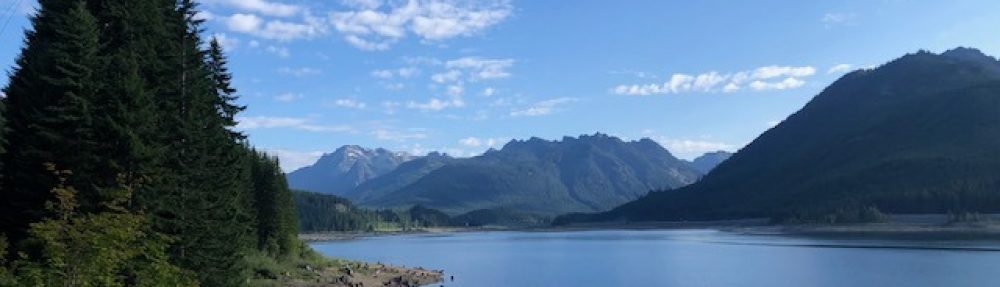
The venue for the run was in Pachaug State Park.  Over the course of the marathon we hit the Pachaug, Nehantic & Quinebaug trails. The double loop marathon course also took us up/down Mt Misery, Breakneck Hill & onto Hell Hallow Road.  As road runners we love our roads.  Up/down or otherwise, the terrain is usually good! 

Pachaug  IMG_2562 

It was a beautiful run.  Very scenic.  Most of the climbs were manageable.

IMG_2557  IMG_2563 IMG_2617

But as I mentioned previously, we spent a lot of time hiking vs running.  I love my trail shoes but if I were to do this again, I’d go with something a lot thicker on the sole.  My feet were pulverized by the rocks.  Plus our ankles and all the stabilizing muscles/tendons really took a beating due to our overall lack of grace when it comes to traversing rocky terrain.

IMG_2616   IMG_6004

Overall, great race.  Great experience.  But we were slow, plus we hit a few wrong turns!  There were only 2 aid stations on the loop, then one at the start/finish.  Everyone carried hydration packs and that was very necessary since the aid stations were spaced out and the time it took between aid stations was pretty long, particularly for us since we were riding the struggle bus. 

We did have a slight issue on loop 2.  We hit the 2nd loop with plenty of time to spare but we were last.  Like DFL (dead fuc*ing last) and the Balloon Ladies sweepers were following us, cleaning up the signs and markers.  We were kissing the cutoff times & the first aid station had been cleaned up before we got there.  Slight stress since some of the crew was out of water but the 2nd aid station was waiting for us.  THANK YOU!  Everyone was super nice.  And we even had a lady in a truck that kept meeting us at intersections, checking on us, who was kind enough to tell us to “take our time”.  Very thankful that we were able to finish.  We did beat the cutoff for the entire race, which was 8 hrs.  We finished in 7:41.  Yes, new PW.  As my buddy Todd so kindly pointed out, if my PW keeps increasing, it will eventually get to the point where it will be UNBEATABLE.  Why thank you, thank you for that. 

Thanks to the Indiana/Illinois crew who traveled & ran with me.  No idea how I have any friends after some of these “adventures” but this crew usually shows up to either bail me out or suffer with me.  Thanks, guys!! Me, Matt, Julie & Todd.

IMG_2552

SWAG – Buffs are all the rage now.  Who knew that 2020 would be the “year of the buff”. 

IMG_2565

Pachaug was my 58th marathon (or longer) & my 34th of the 50 states.  Connecticut is in the DONE column.  Beautiful part of the country.  I’ll definitely go back!

**  Happy Running ** Amanda – TooTallFritz

Tobacco Road Marathon Race Review

Its been six weeks since the Tobacco Road Marathon but I still want to review the race for those who might be interested in putting this on their future calendar. 

logo

The Tobacco Road Marathon was on March 18, 2018 in Cary, NC.  Close to Durham & Chapel Hill.  The race venue is the Thomas Brooks Park & USA Baseball Fields.  Race is  traditionally held on a Sunday and requires travel to the area on Friday or Saturday to pick up race packets.  Small expo at a local hotel.  Easy & fast, in and out.  A few vendors, like my favorite girl, Gypsy Runner

If your traveling with the family, there isn’t a lot to do in this area (or maybe we just didn’t know where to look?).  Beautiful area though.  New neighborhoods.  Nice homes.  Cute boutique like shopping areas.  Nice.

Race day started bright and early like always.  Getting to the race site required some planning.  There was a local pick up area in Cary called NetApp, where people could park & get shuttled to/from the race site.  There were a few onsite parking spots that required pre-purchased parking passes.  Then there was runner drop off at the venue.  Fortunately, my daughter now has her license.  GASP!  She was able to drop me off, then drive back to the hotel with her little brother, then return to pick me up.  This race would have been challenging, logistics wise (as a mom with kids & no other adult to supervise), had she not been able to drive.  I’ve taken them to a lot of races & I usually pick a hotel on the race course or close to the start/finish so they can sleep in at the hotel, then come to the race when they are ready.  This race started at the park, then ran to the American Tobacco Trail, stayed on the American Tobacco Trail, then ran back to the park for the finish.  You need access to a car to get to packet pick up and to/from the race.  No shuttles for local hotels.  No way to spectate without access to a car.

On to the race!  The important part, right?  Please note that the majority of these photos are courtesy of Amy at Gypsy Runner.  I wanted to ring the PR bell, so knew I couldn’t waste time with photos.  Thanks, Amy for always helping me out!  I love seeing your smiling face at expos and out on the marathon courses! 

We got to the race early.  The race started at 7am but the parking areas shut down at a certain time.  I think they wanted everyone in the parking area by 5:30 so that the shuttle buses could come/go without issue.  It was cool.  Probably upper 40s at the start and while we were waiting.  I rarely take throw away clothes but did this time because I wasn’t planning to check a bag.  The plan was to run the race, finds the kids, leave.  We were headed to Disney World for Spring Break & this was just a pit stop for momma to grab another state! 

The race started promptly at 7am.  Start/Finish area was easy to find, just down from the row of port-o-potties.  It was still dark when we started the race but the area was well lit around the bathrooms & the start/finish area.  Photo courtesy of the Tobacco Road Marathon Facebook page:

29356452_1926146864081777_8408117364956069888_n

We left Thomas Park with an incline to get out of the park and onto the road.  Key to remember because that’s a downhill to the finish line!  Couple other rolling hills in the 2.5 miles from the park to the American Tobacco Trail.  Then the marathoners had 21 miles on the ATT.  Very few turns.  If you are ever afraid of getting lost, this is the type of race for you.  There was never any question as to where to go or where to turn.  It was very well ran, volunteers were great.  All road crossings were patrolled. 

The race was advertised as fast & flat.  As a Midwest gal, I know flat.  Any race that claims to be flat, will probably have more hills than I can get when I make an effort to FIND hills to run.  I wasn’t sure what to expect with this race.  I will say that it was pretty flat.  There were a few rollers to/from the ATT.  Once on the ATT (where we ran 21 of the 26.2 miles), it was pretty flat.  This was an old rail trail.  So the inclines/declines were not visible, you’d just feel it in your legs.  On a slight decline, you could feel the load lighten and the pace got easier.  On the incline, you couldn’t really “see” it but you could tell you were going up because it took more effort to hold the pace.  But honestly, I heard some people complain post race about the elevation, Garmin showed 735 ft of gain, Strava showed 819 ft for the entire race.  Small gains & losses over time.

The ATT was a mix of crushed limestone and asphalt. Mostly tree lined with giant pines which provided a break from the wind and the sun.  Temps started in the upper 40s but climbed to the 60s while we ran.  Humidity was low to non-existent.  I don’t do well in heat & humidity so while I did notice that it was getting warmer toward the end, it didn’t effect my performance.

29356678_10156067479983950_4719886273362264064_n 29366467_10156067480358950_8761371454320148480_n

There were 9 aid stations on course, most of which we hit 2x since the trail was an out and back.  All stations were well stocked with fluids, food items & there were port-o-potties! 

On the ATT, we headed out to the north initially, then flipped between mile 8 & 9.  Then headed back south, past our point of entry until another turn around between mile 18 & 19.  As always, that last turn around always feels great.  I also am a huge fan of out and backs, particularly when I know people running.  Watching the other runners makes me happy. I like to encourage them, cheer for the fast people at the front & it distracts me from the task at hand. 

Not a ton of spectators.  Logistics put most spectators at a trail head that intersected with a road we were crossing.  Some dogs.  A few signs.  But everyone was enthusiastic & encouraging. 

29315161_10156067482123950_5508564976123510784_n   29425117_10156067486563950_4603038526978654208_n

I really liked this race.  I picked it for a few reason.  Fast, flattish, few turns, smaller number of runners & the fact that most of it was on a rail trail which would feel a lot like my old training runs.  Some people run better on Saturday mornings with their friends than at big venues with long waits & a bazillion spectators.  I’m probably more of the Saturday morning girl than the “wait & shiver for 2 hours before the major marathon” girl. 

I knew I wanted to try to run faster since I’m not allowed many races this year.  I’m in the midst of training for Ironman Lake Placid.  When I run less races, I’m faster.  No brainer there.  And my back is feeling the best it has in several years.  I’m not 100% but to be honest, this is probably as good as its going to get.  Also, it was important to plan and execute a race strategy, just to know that I can do it.  After Lake Placid, I’m going to take a break and then see if I can qualify for Boston.  This race time was not anywhere what I need to run a BQ but it was all about planning & executing. 

I did have a snafu leading up to the race (pulled something in my foot) so went with Plan B vs Plan A, in the name of being smart & facing down a lot more training for Lake Placid in the next few months.  I started with the 4:10 pacers with the plan of running away from them before the finish.  I figured I could easily gain a couple minutes and drop into a 4:08 before I hit the line, if I was smart.  That’s really the hardest part, being smart.  And patient.  The first half of the race feels so easy, its hard not to just go with it and run faster.  Well, take my advice, going faster than the plan is a good way to blow up.  I used to run less races & try to go faster but I always blew up.  I would go out too fast!  Every time.  That’s really how I started running more races.  I decided that I worked too hard for ONE race, for it not to end in the result I wanted.  I decided I could run  A LOT of races and have a A LOT of fun, and  really my times weren’t any slower than going out too fast & blowing up. 

Anyhow, shout out to the 4:10 pacers.  They did a great job.  I even dropped back 2 different times to get something out of my FlipBelt.  The one pacer checked on me both times & basically “yelled at me” to close the gap & regain contact.  I will say that the added pressure that someone was waiting on me did help to make sure I didn’t fall off pace.  They even told the runners to start floating away from them as we got close to the finish, that a pacers job was to finish alone, on time, with all their runners ahead of them.  Smile  I had already started moving ahead after we got off the ATT in the last 2.5 miles.  That was the last thing I heard them say as I was pulling away.  And I was able to ring the PR Bell at the finish!  4:08:09 was my chip time.  Good day!

29425540_1709686942387783_6983666889729769472_n  IMG_6240

Overall a great race.  There were 1088 full marathoners that started the day, 884 finishers.  The half started 2277 runners & 2202 finished.  Great race, if you are looking for a fast run.  Since most of the race is on the trail, the camber of the road is not as much of an issue as in other races.  Not too crowded. Just enough aid & support.  Low entry fee!  Definitely a good one. 

This was my 27th state, 49th marathon.  My 50th marathon will be at the end of Ironman Lake Placid.  Now that’s going to hurt.  LOL!

** Hope you are all healthy & running happy ** Amanda – TooTallFritz

The Huff 50K Trail Run …. 2017 Edition

Saturday was the annual Huff 50K Trail Run.  Huff is known for bringing something new and unique each year.  The 2012 race brought epic flooding.  2016 brought 6 inches of fresh powder to the start and then added freezing rain atop the snow (and us) for the entirety of the race.  2017 will go down in history as one of the coldest years on record.  Temps at the start were below zero with wind chills, then plummeted further thru the day for an average of –13 to –15 “feels like” during the bulk of the race.  It was a long day for those who were able to finish and there was a large number of runners who had to drop out, or were not allowed to continue after the completion of the first loop, due to weather related concerns.

Huff logo

The Huff 50K offers a 1 loop “fun run” of approximately 11 miles, a 3 person 50K relay & a 50K trail run.  I’ve ran, and managed to complete, the 50K every year since 2013.  I’ve had good years & bad years.  Ones that were tough because I wasn’t up to par physically.  Ones that were brutal due to weather like 2016 & 2017.  I love this race and will continue to run it as long as I am able.  It’s a great way to end my racing season each year.  Its close to home.  And  love that we can pick up our packets the morning of the race!  Win, win, win!

This year, due to the cold temps, I left my phone in my check bag.  My iPhone has a very short battery life & the cold kills it almost instantly.  None of the photos you see in this post are mine.  Thanks to Tadd B, Stacey H & Sara P for sharing their photos so I could add something visual to this write-up!.

Pre-race with Tadd B & Pat H.  I’m the one in bright orange. 

IMG_5743

The race started at 8am for the 1 loop runners.  At 8:20 for the 50K runners.  The course is different for each race.  For the 50K race, there are 3 aid stations on each loop.  Located at miles 4, 8 & 14.  Then the warming tent at the start/finish which is also the half way point of the 50K can be used as an aid station.  Other than the aid stations, there are only a few road crossings.  This is not a race that you can cut short in very many places if an injury, illness or other issues result.  I heard some criticism from some who were not allowed to go out for a second loop of the 50K due to time & weather issues.  I can say from a safety standpoint, it was imperative to have runners off the trail by dark.  Then if we add in the weather concerns, the second loop of the 50K was cold. Really cold.  Plus the trails were drifting from the blowing wind & snow.  It was a bit of a challenge.   I had to have my face covered almost the entirety of that loop to avoid frostbite. Our bodies were burning extra energy to try to keep warm, in addition to the running, so fueling was a huge issue.  And the volunteers at the aid stations were FREEZING trying to support us.  More respect needs to be given to the race officials and volunteers for these races.  Nobody wants to cancel or shorten a race.  Its bad publicity, especially in this age of social media.  However, they are liable for each and every runner.  They have to do what they think is best for everyone, runners & volunteers included.

We had about 3” of snow on the ground.  Flurries during the race. Roads were iced over with a little snow on top.  It was a much better situation running wise than the deeper snow and freezing rain of 2016.  However, it was still a tough race.  Tough but beautiful.IMG_5751

IMG_5735  IMG_5736 IMG_5745

IMG_5734 IMG_5738 

IMG_5740

Lots of hills.  Lots of slipping and sliding.  Running for most of us was slow going.  I was amazed by the varying degrees of dress.  I was focused on keeping my face covered to avoid frost bite, yet there were people running in shorts, or less.  The conditions were dangerous.  I wouldn’t recommend running with exposed skin when the temps are below zero. 

Sara & I in the pines on loop 1.  One of my favorite areas. 

26169643_10156192795089238_8842673022514052564_n

Pure joy as we cross the half way mat (after I stopped to put on my yaktrax). 

IMG_5758 IMG_5761

And then the wind hit us.  Cold.  Strong.  Blowing us around.  Trying to cover the tracks of those before us.  Time to put our heads down and just run.  The yaktrax were a welcome addition to loop 2.  They helped A LOT in the areas that were packed down and in the slippery areas.  I wish I had worn them for the first loop but thought the snow was probably too deep for them to do much good.  I’ll definitely wear them for all snowy trail runs going forward.  My footing was a lot better after I put them on. 

The wind made the temperature drop further but I was warm.  My clothing was perfect:  Athleta Polartec tights, Injinji over the calf compression socks, thin Under Armour Long Sleeve Infrared tech shirt, Nike Pro Hyper Warm Fleece Lined 1/2 Zip, Saucony Vita Run Vizipro jacket, ear band, hat, balaclava, lined gloves with a an extra pair of throw away gloves that had hand warmers inside.  I used the throw away gloves with hand warmers at the start for a several miles, then again on loop 2 after a lengthy stop at an aid station.  Only difference between loop 1 & loop 2 was that I had to keep my face covered the majority of the second loop due to the added wind. 

Best Aid Station Ever at Dock Lake.  Team Tritanium ran the aid station again with the Huff Couch.  Two fires were burning.  Smores, gluten free chicken noodle soup, homemade sweet bread, plus the usual ultra fare. 

IMG_5749  IMG_5737

But really the best part is always the finish.  My 5th Huff 50K is in the done column.  I hope to be back for #6 in 2018.  See the finishers medal and cool handmade soup mug below.  Lots of fun. 

IMG_5790  IMG_5728 

IMG_5755

Finisher stats:  50K – 118 Finishers, 57 DNFs; 1 Loop Fun Run:  139 Finishers, 5 DNFs.  Relay – 24 Finishing teams, 5  DNFs, 3 DQs. 

As always, a great race.  If you are going to run in the winter, I’d recommend layering up and minimizing exposed skin.  There will always be people running with very little on but honestly, that’s just not safe. Be smart & enjoy the beauty of the season.  Running is a great way to get out and enjoy the winter months and keep those Winter Blues away!

** Happy Running ** Amanda – TooTallFritz

Wildwood Trail Marathon Race Review– Wildwood MO

I ran the Wildwood Trail Marathon in Wildwood MO on Sunday.  It was my 47th marathon (or longer).  I’m a runner who loves to run.  I love the trails and the serenity.  However, I’m not a real trail runner.  Let’s not squabble over the fact that “if I run trails, then I’m a trail runner”.  You know what I mean.  I’m a road runner.  I enjoy the road under my feet.  A solid surface that does not move.  One where I probably won’t trip over something that I can’t see because its covered by a forest of leaves.  One where sharp rocks don’t jut out at every step.  One where if I fall, I won’t stress about sliding down the bluff in the process.  Road runner.  Yep, that’s me. 

wildwoodtrailmarathonlogo_2

Now that is has been clarified that I’m a road runner, my report follows. 

The Wildwood Trail marathon is self described as scenic & fast.  Good for road and trail runners, experienced and beginners alike. I’ve ran a lot of road races, plus my fair share of trail races.  So I feel well versed and able to give a realistic point of view.  Scenic, yes, in spots.  It’s a beautiful run thru the woods.  This race, unlike others I have ran, consisted of a lot of rock based trails.  Most trail runs are on dirt trails.  Wildwood has a lot of rock.  Not to make this too simple but the bluffs are made of rock.   The dirt wears away & only rock is left in spots.  Second pic below shows it well.  That looks like a well worn dirt trail, right?  No.  Its solid rock.  Somewhat smooth surface in some spots.  Jagged rocks sticking out in other spots.  Pics below are from the Bluff View Trail.

IMG_5485  IMG_5488 

The race started at a school, right off the Hamilton-Carr paved trail.  Then we hit a crushed stone & dirt type trail called the Al Foster Memorial Trail.  This lead us to the first detour, the Bluff View Trail which was about 2 miles into the race.  That’s where things started to get interesting.  The trail (seen above) was 2.5 miles of single track, some slanted to one side or the other, winding up the Bluff for an awesome lookout.  The Bluff View Trail provided some of the most scenic views of the day to the Crescent Valley below.

IMG_5489  IMG_5490

After climbing the Bluff Trail, we made a small loop & returned the same way we went up. I must say that after staring at the course map for days, I really didn’t understand it.  But thankfully, the race was marked very well and there was never a question as to where we were headed.  Course map below.  One note, it would have been super helpful if the course map had mile markers.  For those of us unfamiliar with the area, we never really knew where we were at any given moment.  I had the map in my head but as you are climbing, climbing, climbing and maneuvering the switchbacks, everything is very focused.  It would have been great to know that I just had to manage the climb/terrain until mile x, then I would get some relief. 

image

December can be tricky but we had a beautiful day with the sun shining on us.  Made me happy.

IMG_5508

Dry trails.  Leaves cushioning the rock.  And a few breathtaking views.  After the Bluff Trail, we hit the Rock Hollow Trail with the infamous Zombie Heights.  This was by far the toughest section (on the map it’s the tall section of zig zags, middle of the map) and I was zombie like, just watching the ground and trying to navigate the terrain.  Rock, switchbacks, lots of technical sections, all on a single track of rock and/or dirt.  We spent a lot of time hiking in this section for safety reasons.  My legs felt good but I can only go as fast as I feel safe.  I’m not a super coordinated person.  I’m not exactly clumsy but I do try to be careful.  So we saw a lot of 20  minute miles in this section.  Took forever to get thru it.  This was approximately mile 6 through 14.  Pics below of this section show the varied terrain.

 IMG_5492 IMG_5497 IMG_5502 IMG_5504 IMG_5510 IMG_5507 

After Rock Hollow and Zombie Heights, we had a nice flat section back on the Al Foster Memorial Trail heading to Sherman Beach.  Easy terrain.  Well packed.  Fast section. 

IMG_5515

Sherman Beach was a hot spot.  By the time we got there, a lot were already headed back to the finish.  Lucky them.  But this was an important area.  First, the only port-o-potty on course was here. It was also the 3rd & 4th aid station.  And this is where the cut-off happened.  Once passing thru the Sherman Beach aid station (mile 15.5ish), there was a 7.5 mile loop.  We had to be back to that aid station by 2:30pm or we wouldn’t be allowed to finish.  Technically we had plenty of time.  But if we ran into a section of 20 min miles, then the cutoff was in jeopardy.  I must say this is the first time I ever really thought about a cutoff (in any race) and it was stressful! 

Leaving Sherman Beach we had a short section of flat, well groomed trails.  Then we hit the tunnels.  Concrete, manmade tunnels.  I had to bend over and walk thru them, they were short in height and long in length.  A volunteer on a bike told us that he would see us in 2 miles, once we hit the tunnels.  Must say this might have been the longest 2 miles of my life.  The tunnels lead to the Cedar Bluff Trail.  Obviously a short 2 mile jaunt.  Not as technical as the Zombie Heights but we had to be on our toes. And we were apparently rushing because of the cutoff.  Both my run partner & myself fell in this section.  Hard.  Blood & bruises the result. 

IMG_5517  IMG_5518

Once we were back to the tunnels, things got much better.  We hit a network of trails by the Meramec River.  These trails consisted of dirt & sand.  Well groomed.  Lots of people riding bikes, walking dogs & hanging out.

IMG_5520 IMG_5519 IMG_5526 

And then eventually the Stinging Nettle trail which was a sand trail taking us back to the 4th aid station at Sherman Beach.  Well AHEAD of the cutoff.  Smile   Tamyra below on the Stinging Nettle trail.

IMG_5524

After Sherman Beach, there was an easy, flat run back to the finish on the Al Foster & Hamilton Carr trails.  Photographer caught us in this section.  Yep, I’m dirty.  I fell down somewhere along Cedar Bluff.

 IMG_5528 

IMG_5543

This marathon was approximately 25.77 miles.  If you are a 50 States Marathon Club runner who is trying to run all the states, don’t use this one for Missouri or you’ll be short & it won’t count.  Trail runs are always questionable in distance since you go where the terrain takes you.  Very normal. 

So, was this race scenic & fast?  Yes. Obviously scenic.  But its also one of the faster trail marathons that I’ve ran thanks to several flat sections where you can run faster.  Good for beginners & experienced runners alike?  Maybe.  The flat sections help a lot.  But there was a lot of technical spots too.  Anyone can do it.  But they really have to be invested in it.  So yes, good for anyone as long as they are committed & ready to go the distance no matter what the trails present.

Overall, great race.  Great volunteers.  Only 4 aid stations.  Stocked with trail running basics:  Coca Cola, Ginger Ale, peanut M&Ms, cookies, pretzels, oranges, pickles, electrolytes, Hammer gels.  Water & Heed (a Hammer product).   This was a cup free event so everyone needed a handheld, water bottles or collapsible cups to utilize the fluids on course. 

Small event.  I had read before race day that there were 209 entrants.  Not exactly how the results panned out.  I’m not sure if everyone was listed but they show 89 finishers.  I was #81 (6 hrs 30 min).   3 DNFs.  8 DNS. Winning male:  2:52.  Winning female:  3:44.  So it was apparently a fast race for some.  Smile Cutoff was 8 hours.  Last finisher was 7 hrs 51 min.

SWAG:  Beanie, Hammer gels, Hammer Endurolytes, sample pack of Biofreeze, finishers medal & FREE race photos.

IMG_5549

That’s a wrap on this marathon!  If your interested in trail running, I’ll link to some of my other trail runs below.  The hardest I’ve done so far is the Eugene Curnow Trail Marathon in Duluth, MN.  That race is the warm up for the Minnesota Voyageur 50 miler.  God help those 50 milers.  They are tougher than me!  My second hardest trail marathon was the Dances with Dirt Devil’s Lake Trail Marathon in Baraboo, WI.  Easiest trail run/ultra was the Lakefront 50K in Chicago.  If you  need a fast 50K time, go to Chicago.  Race is on a paved path along Lake MI.  Fun.  Easy. 

Trail Race Reviews (minus the 2014 Huff 50K, which apparently I didn’t write up?!?):

Next up the 2017 Huff 50K on 12/30.  Then I rest. 

Happy Running, all!  ** Amanda – TooTallFritz

Huff 50K Race Report – 2015

Huff logo

My third Huff 50K is in the books!  As I mentioned on the TTF Facebook page yesterday, this is a race that just makes me proud to run.  Proud of myself for going back to a tough race year after year.  Proud of my run friends who brave the elements and trails, when they would rather be pounding pavement.  Proud of the other participants who are constantly encouraging and showing the newbies what trail running is all about.  Proud of the race organizers for delivering a great race over and over again.  The Huff 50K is a class act.  Pic below from top is the 2013, 2014 & 2015 belt buckles.  Maybe I should buy a belt?

IMG_9131

This event is at Chain O Lakes State Park in Albion, IN.  It offers a 50K, 50K Relay & a one loop option (10.8 miles).  Lots of choices.  The trails are well groomed, wider, not single track like many trials.  This is a great event for beginner trail runners and a great course to run side by side with a friend/partner.  Aid stations are spaced about 4 miles apart and there are bathrooms and/or port-o-potties at 4 of the 5 aid stations.  This is huge and not the case with all trail races.  I would recommend carrying your own water to manage hydration between aid stations.  Trail shoes are recommended by not required.  I like to use gaiters over my shoes to keep leaves and debris out of my shoes/socks but these are not a necessity either.  This is a very user friendly trail event.  No fancy equipment required.

There were a few changes for 2015 both at the organizational level and on the course.  I think everything went very smoothly.  My brain struggled with the new course, always trying to figure out which way we went last year, but I just followed the pink markers and it went well.  No idea if this course was easier than years past but this was our fastest year thus far at Huff (6:50 finish).  There were a lot more markers this year and even a few spots where they put up tape so that runners didn’t get off course inadvertently.  Nice touches that I really think helped the comfort level of the newer trail runners.  I never had an issue before at this event but I’m an “eyes to the ground” trail runner so that I can watch my footing and the trail markers.  The new course and markings allowed for more social running without fear of missing a turn off.  I think Huff is a social trail race.  So many people sign up because their friends are going, even if they have never ran trails before ….. and that’s why its FUN.  New course below.

   Huff_map_2015

Great aid stations.  If you haven’t ran an ultra or trail marathon before, you might want to do so just for the food.  There is candy, m&ms, twizzlers, cookies, fig newtons, pb&j quarters, potato chips, pretzels, soups, boiled potatoes with salt, coke, water, gatorade, lemon bars and one spot was even grilling hamburgers.  So much food.  I didn’t bother carrying any gels and my tummy thanked me for eating real food.  Spirits were particularly high on the first loop.   Myself, Tamyra & Julie getting ready to tackle the hill in the background.  Hills, smillz.

IMG_9113

We ran the first loop in 3 hrs 15 minutes, which was my goal.  Then I thought we could hit the second loop in 3:30 but I was off a bit, took us 3:35, which is still good in my book.  That second loop gets really LONG.  It’s almost like you cross the mat at halfway and they add a couple bricks to each leg.  The hills suddenly seem steeper and each mile drags on a bit more.  But we just kept moving thru each mile (marked signs at EVERY mile!) and toward the next aid station.  It worked.  We didn’t rush.  This isn’t really a race for us but more of an experience.  So if someone need to walk or potty, we stopped.  We probably spent too much time at a couple aid stations but oh well.  Over all, we kept moving!   And we tried to keep it fun.  When Julie’s hubby started texting her (probably wondering if we were done yet!  Ummm, no we were not done!), I insisted we stop and take a selfie to send him.  Hi, Joe!   I was getting ready to stick out my tongue but we snapped the picture first with my crazy face.  That’s about right, I was feeling kinda crazy that far into the race.  I think we were probably around mile 28 at this point.  The craziness had definitely set in.  Tamyra, Me, Julie.

IMG_9141

I’m very thankful that Julie came back for her second Huff this year.  I know she didn’t love it last year.  She doesn’t love trail running at all but we still do a couple trail marathons each year.  Totally my fault. It always seems like a good idea at the time.  Smile  And this was Tamyra’s first ultra.  Her third marathon distance event (or longer) since November 7th in Indy when she ran her VERY FIRST marathon.  She took a leap of faith and followed us to Tulsa for the Rt 66 Marathon, and then to Huff.   2 marathons and 1 ultra in a 6 week span.  She’s definitely a tough chick and I’m proud to call her a friend!  Great job,Tamyra!!!

The swag.  Huff always provides good stuff.  This year we got a cotton tee, a Huff Santa Hat, a portable charger & a key chain with a thermometer.  Then here is a close up of the belt buckle that was received at the finish.  Most 50Ks don’t offer a belt buckle, but rather a finishers medal.  So it’s a nice touch for Huff to give the buckle and that’s probably why this is one of the largest 50Ks in the US.

IMG_9127 IMG_9142

IMG_9128

Huff is a great race.  I highly recommend it.  Grab some friends and run a loop OR two.  Next year, Huff will be on December 17, 2016.  Then the 2017 race will be returning to the first Saturday after Christmas. 

Side Note:  If you’re in the woods, State/National Park or not, DO NOT litter.  A general rule of hiking, backpacking and trail running is that if you pack it in, you pack it out.  I saw A LOT of litter & debris on the trails this year.  Very disappointing.  Someone has to clean that up or Huff could get fined, get belittled by other races or worse yet, lose their permit to run at Chain O Lakes.  Please respect your environment.  Don’t drop GU packs, kleenex, hand warmers, cups of noodles, or your SWEATSHIRT on the trail cuz you are tired of carrying it.  The aid stations are close enough together that it isn’t a stretch to hold onto your trash for a little bit longer and dispose of it property.  Please.  Respect your trails or they will be gone.  Help protect the trails for all of us, our kids, and our grandkids to come. Thank you!

IMG_9114

2013 Huff Race Report, must have neglected to write one for 2014.  Ooops.  Smile

** Happy Trails ** Amanda – TooTallFritz

Happy Thanksgiving & Let’s #OptOutside for Black Friday

Happy Thanksgiving

Hey, all!  The holidays are a wonderful time of year, full of traditions.  Some of us start our day with a local Turkey Trot while others are already warming the kitchen with the smell of homemade pumpkin pie.  I want to wish each and every one of you a joyous Thanksgiving!  I’ll be thinking of you all and hoping that you are surrounded by friends, family and someone who loves you!

thanksgiving

The holidays are full of tradition.  When I lived in IL, I would always host a Black Friday run at Waterfall Glen.  There wasn’t a hashtag for #OptOutside.  There wasn’t a big corporation behind the movement to get people outside.  Nobody was talking about health, wellness, fitness, friends or family on Black Friday.  No, they gave their thanks on Thursday and moved on to retail madness on Black Friday.   Some big retail chains are saying NO this year.  REI in particular started the push to #OptOutside for Black Friday by giving all of their employees the day off with pay.  Many other retailers has followed suit.  I encourage all of you to #OptOutside for Black Friday.  Let’s wait for Cyber Monday to get all those amazing deals for our little angels, from the comfort of our home, where we can shop in our PJs.  That’s what I’ll be doing. 

If you need a place to go on Black Friday to #OptOutside, I’ll be leading a group run at Pokagon State Park, in Angola, IN.  Details HERE.  If you don’t want to follow me, then you can follow Lilo.  She promises an AMAAHHHZING trail run!  Or if you aren’t close to us, then REI has a link HERE to find a place to #OptOutside.

Lilo

** Let’s Hit The Trails With Lilo & #OptOutside on Black Friday ** Amanda – TooTallFritz

Eugene Curnow Trail Marathon–Duluth MN

As most of you know by now, I’m on a quest to run a marathon in every state.  And I’m on a budget.  As a result, I’ve pretty much given up running races that are less than the 26.2 distance.  I’ve also pretty much given up running marathons in state’s that I’ve already “checked off” unless the race is free.  I pick races based on my (and Julie’s) calendar.  I don’t stress about the course.  Or the weather.  Or the details.  It’s an adventure.  The bigger, the better.  The more the merrier.  Join me!!

logo

We picked our Minnesota race because Julie said she wanted to knock off MN this year.  I can’t say this was my first choice for MN because, well, we are road runners!  But alas, it   fit into our weekend warrior calendar and it was super affordable at a mere $35 entry fee.  You absolutely can not beat trail races for the price, the hospitality, the fun and the level of commitment that they give to each and every runner.  The Eugene Curnow Trail Marathon wins the TTF Award for the “Best Bang for the Buck” in 2015.  I don’t even care that it’s only July.  They already won.  $35 entry fee = $1.34 per mile.  Our race took forever 7 hours & 37 minutes = $4.60 per hour.

The aid stations were stocked with coke, ginger ale, sprite, powerade (BLUE!!!!), ice, ice water, pretzels, M&Ms, candy, fig newtons, sandwich cookies, frosted oatmeal cookies, gingersnap cookies, potato chips, watermelon, bananas, salt, salt capsules, and a ton of stuff that I can’t remember.  I probably ate/drank more than the $35 entry fee.

There was also an army of volunteers who encouraged us, filled our water bottles, wiped our tears, recorded our numbers, pointed us in the right direction and handed us paper towels & wet wipes in case we needed to go to the bathroom clean up.

The race started promptly at 6am at the Lake Superior Zoo.  There was no big start banner.  No chip timing.  No pomp.  No circumstance.  But there were people making announcements to get us in the right spot and there were bathrooms. Runners came to run and everything else is left on the trail.

The first 2.5-3 miles of the race climbed the ski trails of Spirit Mountain.  Once we started hitting nice roads and fancy bridges we knew we were close to the top!

IMG_7539   IMG_7540

Then we started seeing the ski lifts and we came out of the trees for breathtaking views of Lake Superior in the early morning fog.  Absolutely amazing.

 IMG_7534         5

The trail was very well marked with orange ribbons.   I never once questioned our direction.  Organizers spent a lot of time clearing trail for us rather than just using ordinary trails already cut in the parks through which we ran.  There was a lot of planning to get us from Duluth to the finish in Carlton, MN on this point to point course.   It was a creative path.  A difficult one.  Not the most technical of all that I’ve ran but extremely hard and probably the most fun so far (and that’s saying a lot cuz we ran the Dances with Dirt Devil’s Lake WI Extreme Trail  Marathon last July).  Take a peak at the various terrain from steep trails along ridges, to roped off trails to help us navigate the terrain & not fall …..

IMG_7547  IMG_7568  IMG_7551

To hills, both up and down as far as the eyes could see.

IMG_7577  4  IMG_7579

Beautiful ferns.  Bridges.  Obstacles.

IMG_7572  IMG_7574  IMG_7575

Water crossings.  Mud.  Roots.  Rocks.

  1  2  IMG_7594

Parks.  Rivers.

IMG_7592 3

Every step of this was amazing.  And hard.  Very hard.  But we smiled and laughed almost the entire 7.5+ hours.  If you are a trail runner, the Eugene Curnow Trail Marathon is a must.  If you are an ultra runner, then this race is just a warm up for the MN Voyager 50 Mile Trail Ultramarathon at the end of July.  Like what you see in these pics?  Try the Voyager and you’ll get to run it twice.

As you know from the above post, we finished.  And were happy to see the car and some clean clothes at the end of the race.  To our surprise, we also received a very unique handmade finishers medallion and a gender specific soft, tee.  Nice!

IMG_7603

I’m forever grateful for the good friends I’ve made over the years while “on the run”.  A special thanks to Julie for running some of these crazy races with me!  I can’t wait til we tromp off into the woods for the next adventure!  IMG_7590

** Maybe We’ll See YOU On the Trail ** Amanda – TooTallFritz

Fox Island …. Ft Wayne, IN

IFox Island Nature Perserve

7324 Yohne Rd.
Fort Wayne, IN 46809

As you  know, I like to explore new trails.  I particularly like ones where I can take the kids and a dog (or two) and get everyone out of the house just stroll along in the fresh air.  Fox Island County Park is one such place.  See excerpt from the Allen County Parks Department webpage below:

Fox Island is a 605 acre park located in southwest Allen County. Within this park, 270 acres are dedicated as State Nature Preserve, which protects areas having unique plants, animals or geographic features. Hundreds of species of animals and plants live at Fox Island because of the relatively natural condition of most of the area, with its habitats of marsh, seasonal ponds, wooded sand dunes, wetland forest, old fields and restored prairie. The park contains the largest contiguous forest in the county and a glacial sand dune

When I moved to Indiana, just north of Fort Wayne, many people suggested I visit Fox Island for running.  After reviewing the maps and website, I was thinking it would be a better place for a family excursion verses a running adventure for myself.  There are 7 miles of short trails winding thru the forest but they are flat and perfect for a family hike.

IMG_6726  IMG_6725

The trails never venture too far from a road or intersection.  There are markers throughout the park identifying trails, trees, plants, flowers and even a bit of history.  Some trails are dirt, others grass.

foxislandtrailmap

Wildlife is buzzing on and off the trail.  Perfect destination for the family and most trails are groomed well enough for a 3 wheeled jogging type stroller. 

IMG_6729   IMG_6730

And there are bridges.  And a beach on Bowman Lake for playing and swimming (stock photo).  Plus fishing areas.

IMG_6735   Fox Island Beach

Fox Island has a beautiful Nature Center with a classroom, which is available for rental.  We went on a Friday night and if I remember correctly, there was a scrapbooking event in the Nature Center.  I neglected to get a photo of this area because Michael was super excited and starting running toward the docks behind the Nature Center which have a great view of the pond, wildlife and the surrounding trails.  Even if you have a member in your group who isn’t able to walk the trails, you can always drive them to the Nature Center and have a look around in that area without doing much walking.  Very nice. Scenic.  Handicap accessible.  And peaceful unless you have a 5 year old screaming and yelling with excitement

There is an entry fee for Fox Island.  When we were there, nobody was at the gatehouse taking admission but we stopped and dropped our $2 per person fee into the drop box.  I did notice that most were just driving in without paying and while it’s easy to do that, I always try to support these types of forest preserves because I know that funding is hard to come by and I enjoy being able to explore new areas.  Without funds, places like Fox Island will close and be lost to the public.  If you drove in and forgot to leave your entry fee, you can join or make a donation to the Fox Island AllianceWinking smile

See you on the trail!

Amanda – TooTallFritz

Pokagon State Park–Trail Running

Trail running can be intimidating but it doesn’t need to be scary if you know what to expect.  I’ve ran the trails at Pokagon State Park multiples times now and have found it to have some of the best trails in Northeastern Indiana.  Why?  The trails are accessible year round.  There are a variety of trails from easy to hard, with varying surface types.  All  trails are short and within close proximity to a road, or the Pottawatomi Inn.  Trails are well groomed and wide enough to run with a friend.  Best of all, the trails are marked well.

Hells Pt_sign

And if weren’t paying attention to the last couple of signs, then look at the “You Are Here” maps,  or notes/maps on particular points of interest, which are scattered throughout the trail system.

Hells Pt_map

Pokagon is a place you can go with your family for hiking, swimming, camping or horseback riding.  Or you can run for fun or even train for a marathon or ultra.  It’s good for short distance runners AND long distance folks.  I’m particularly excited to get Aby and some of her Cross Country friends up there this summer!  

I usually park at the Potawatomi Inn and start on one of the trails which begin at “The Inn”.   If it’s dark, I run on the roads within the park until the sun comes up.  Got a great pic last weekend of some of the holiday lights.

Trees

At this time of year, there is little traffic in the early mornings.  It’s a good time to tour the campgrounds, roads and paved trails while there isn’t too much hoopla.   Bathrooms are still open but lacking toilet tissue.  There will be a few scattered campers and park workers moving about in their vehicles.  And the Inn will always have guests who are coming and going. You will not be alone. 

The two trails which are easiest to connect with are those which lead to/from the Pottawatomi Inn.  Trails 1 & 3.  Trail 1 is easy to find by going down by the beach and it picks up to the side of the playground.  A nice easy trail that is in the woods with views of Lake James and some of the houses which surround the water. 

trail 1_start      trail 1

Good trail for beginners or seasoned trails runners.  A couple hills but nothing scary.  If you have a young Cross Country runner, or a new 4 legged friend to train, this would be the perfect trail developing an excitement about trail running while still keep everyone close to people, park roads and The Inn.  Well traveled trail.  Bonus, if non-running family members want to go with you to the park, they can play on the beach and playground while you take a short trail run.  Big win for everyone!!  Trail 1 & 3 highlighted in yellow below.

image

Trail 3 starts in the parking lot of the Potawatomi Inn, in the Northeast corner.  You can park your car and be on the trail in 30 seconds.  In my opinion, Trail 3 is the heartbeat of the entire trail system at Pokagon.  You can access every trail in the Park, plus the Beechwood Nature Preserve loop via #3.  If you ever get lost, run towards 3 and you’ll eventually start seeing signs for The Inn which is why I suggest you park your car there.  The trail starts in the woods, runs across some wetlands with a few cute bridges with benches for sitting.  Great trail, not too technical. 

trail 3_metrail 3  trail 3_benchestrail 3_benches2

Then #3 leads wherever your heart desires, just check the map and go!!  Since most of the trails are loops, if you have a long run to do, you can run most of the trails without backtracking or even thinking too much about what to do, or where to go.  I see a sign for a trail, I just take it.  It generally loops me back to the trail I was standing on when I saw the sign.  Super easy trail system, I promise!!

Hardest Trail  – #9.  This trail takes you up, Up, UP and eventually overlooks Interstate 69 before going back down to reconnect with Trail #3.

trail 9  trail 9_interstate 69

Point of Interest – Hell’s Point, on Trail #3.  I expected it to be harder to get to with a name like Hell’s Point but it wasn’t too difficult, just follow the signs and run the trail.  Fun set of stairs and a nice view from the lookout!

Hells Pt Hells Pt_look out

Hidden gem – Beechwood Preserve Loop, which is not part of Pokagon but accessible from Trail 8.  Lots of wildlife.  Short loop which is good for walkers.  Super secret parking lot off of 127 to access this area and make it a family friendly adventure (no strollers).  Even has a half loop sign if you want a shorter route.  One big hill if you do the full loop.  Yeah, I walked that hill!  Smile

Beechwood loop_off trail 8

Easiest Trail – #7.  Grassy loop with a nice view of a wetland.  Lots of water fowl in this area.  Benches everywhere to sit and rest or watch the wildlife.

trail 7

Biggest attraction:  Toboggan Slides.  Open from the Friday after Thanksgiving thru February.  Yes, I’ll be taking the kids.  Looks super fun and slides pick up speed of 35-40 mph.  Sounds terrifying and exhilarating!  Image source

TobogganRun

Pokagon State Park is amazing, go check it out cuz I know you’ll love it as much as me!  It offers over 1200 acres of fun from water activities to hiking and trail runs.  Great fun for the entire family!

** I’ll See YOU On The Trail ** Amanda – TooTallFritz

Historic Auburn, IN – That’s MY Town!

I’ve been MIA for quite a while.  Moving the family, pets, a house and a pole barn stuffed full of cars and shit 200 miles away takes some time.  Actually finding a house takes a lot of time, then the actual MOVE is never-ending!  However, we are close to completion and it’s time to go explore this new town of Auburn, IN!   Let’s do this!!

Downtown Auburn Historic District

Auburn is a historically rich town known best for it’s work with the automotive industry; however, I’m here to tell you that there is a lot more to Auburn than cars!  The town is amazing.  It’s a small town that takes pride in its community.  The streets are well designed and groomed to make you want to stop driving and get out of your car for a stroll!  Lots of little shops, restaurants, antique stores, boutiques, ice cream & coffee shops around the square.  And flowers.  Lots of beautiful flowers and benches where one can stop and enjoy the views!  Plus there is a local farmers market on Wednesday’s & Saturdays!

Auburn Streets

Auburn hold frequent activities that are great for the entire family.  There are lots of old historic homes in the downtown area that are affordable AND cute (some may be for rent)!  Plus they still have a sense of community where Mom & Pop businesses not only exist but thrive.  Yes, both Mom & Pop still work the store, perform the service and are happy to chat when they see you in streets.  It’s a real sense of community with the courthouse sitting proudly in the middle of town.  And it still looks like a courthouse.  DeKalb County Courthouse below.

Dekalb Co Courthouse 

 Dekalb Co Courthouse_2


I spent some time “running the streets” today.  I ran thru town admiring the streets and businesses.  To the Auburn Cord Duesenberg Museum  and the National Auto & Truck Museum.  Even found the location of a time capsule buried on the property of the ACD museum (go find it!!).

Auburn Auto Co ACD Natl Auto-Truck Museum


But as a runner, my biggest find was a short local trail, the Auburn-Waterloo Bike Path, that I can’t wait to run again, again and again.  The entrance is hidden in plain site on North Street, just east of Indiana.  It travels from North Street to Betz (1 mile), then follows Betz east a few blocks and picks up the path on the east side of 427 heading north toward Waterloo.  Please note that 427 is Main Street, which turns into Wayne Street in Waterloo.  Total distance is 4 miles from North Street to the end in Waterloo.  Nice little jaunt.  And do be careful of broken sidewalks/pavement on the trail/sidewalk along 427.  

trail entrance_north & indiana Auburn Trail Auburn Trail3

Auburn Waterloo Bike Path Auburn Waterloo Bike Path_along 427

Run #1 in the done column in my new area of Auburn, Indiana.  Come run Auburn with me!!  Lots to see and do and it’s a great little town for the entire family!


** Run Auburn ** Amanda – TooTallFritz **